Tuesday, September 12, 2023

Something for Everyone – Olympic National Park, Port Angeles, WA [September 3 – 5, 2023]


Lovely Lake Crescent

Olympic National Park has something for everyone.  You like snow-capped mountains?  They’ve got that.  Pacific Ocean beaches?  They’ve got that, too.  Scenic mountain lakes? Yup!  Rain forests, and sub-alpine forests?  Yup and yup!  So many things to do, and so many eco-systems to explore.


Rialto Beach - Pacific Ocean

Located on (and encompassing much of) the Olympic Peninsula in Washington State, this National Park feels lightyears away from the multitude of metro areas surrounding Puget Sound, even though it is actually only a little over an hours drive by car plus a ferry ride away.  What a wonderful place!


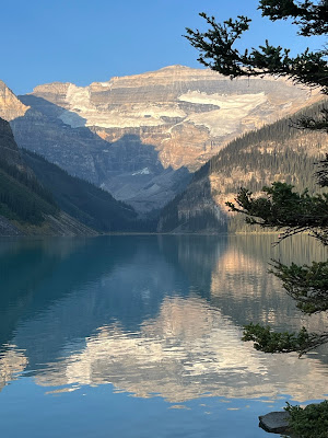
Lake Crescent at sunrise

We camped at the Log Cabin Resort and Campground located in the northern part of the park.  The campground is situated on gorgeous Lake Crescent.  Dark green, forest covered mountains draped in clouds form a backdrop behind the lake.  It was so beautiful and peaceful we were tempted to stay at the campground the entirety of our visit and just soak in the restorative beauty.


We kept driving West until our feet got wet ...

However, we’ve been telling all who asked about our trip that we were “going to keep driving West until our feet got wet.”  We had to leave the lake to find the ocean.  The coastal part of the park runs for 54 miles in a thin band along most of the Pacific coast of the peninsula.  It is separated from the main section of park by National Forest, some private landholdings, a few towns, and a few Indian Reservations. This part of the coastline includes Point Alava, the westernmost point in the lower 48 states.


Quillayute River separated from the ocean by a berm of pebbles and a pile of driftwood

Huge bleached tree trunks line the beach


We visited Rialto Beach where the Quillayute River meets the sea.  Driftwood composed of bleached trunks of massive trees form a barrier between the river and ocean, as the river curves and fans out into a delta before merging with the sea.  The beach is formed of dark, flat, worn, oval pebbles.  Some as big as your hand, some as fine as a grain of sand.  Off the coast stand huge rock structures.  Some devoid of vegetation and some growing brave, hardy trees.


They grow big trees in the rain forest!

After a walk on the beach, we headed to the Hoh Rain Forest, one of two rain forests in the park, and the closest to Rialto Beach.  It is "only” 45 miles away.  The Hoh Rain Forest is one of the park's most popular areas.  It has limited parking, so there is a waiting line to drive in.  For each car that leaves, a car from the line is allowed to enter.


This gauge effectively shows the 2023 rain deficit

The mighty Hoh River carries ice melt from the glaciers on top of Mount Olympus to the sea.  Along its banks, this section of forest receives an average of 140 inches of rain a year.  With so much water, the trees grow really big and their branches and trunks are covered with moss.  Ferns abound on the ground.  A graph at the Visitors Center show the current rainfall in 2023 against the average rainfall.  The Hoh Rain Forest is running a deficit of rain this year. 
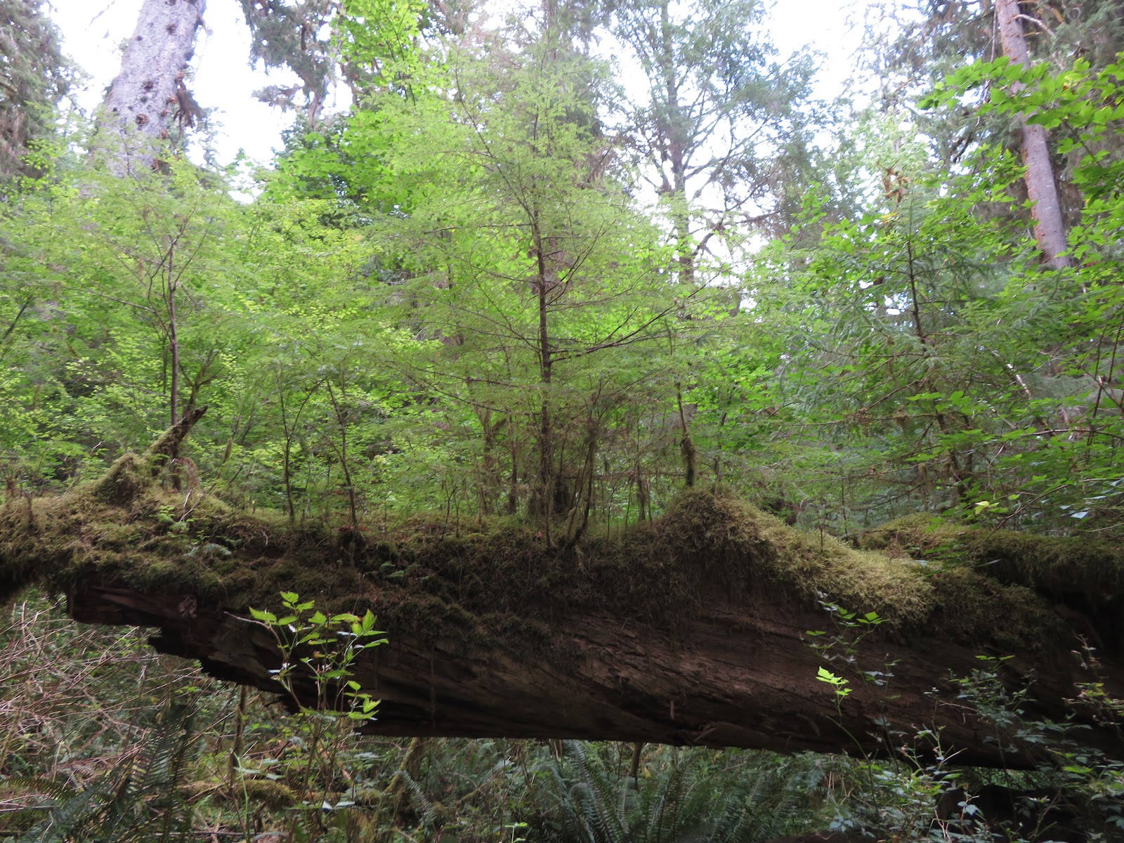
 

Early nurse log


We learned about nurse logs.  When a mighty tree falls, it leaves a gap in the canopy for sunlight to peak through and stimulate new growth.  Tiny plants take root along the decaying trunk, using the nutrients in the old tree to fuel their growth. 


Nurse log with small trees

Over time, a few of these plants grow into trees, and later a few of those trees continue to grow into mighty trees themselves. 


Mature trees still use nutrients from the nurse log


Until the log is all gone


If you see a straight line row of trees in the rain forest, chances are you are seeing the legacy of a nurse log from centuries ago.


They call this the Hall of Moss

Epiphyte lichens and moss do not hurt the host tree


The branches of some of the trees are covered with a lichens and moss.  These are epiphytes, plants that live on the tree, but do not harm it.  They absorb nutrients and moisture from the air.  They are home to miniature creatures like mites, millipedes and spiders.  If you’ve been reading this blog for a while, you might remember that we pointed out epiphytes that we saw at the Corkscrew Swamp Audubon Sanctuary in Florida.


Such a beautiful, wild place

Distances between places are huge here at Olympia National Park.  The Rialto Beach and the Pacific Ocean was 55 miles from where we were staying on Lake Crescent.  Our trip back to the campground from Hoh Rain Forest was 74 miles.  There is one road, 101, that circles this huge, 1 million acres (1,441 square miles) park.  Roads branch off of it into the park, but none cross the park because a glacier topped mountain occupies the center of the park.  While we think that it is enormous, Olympic is only the 13th largest park in the National Park System.


We could all use a quiet day on Lake Crescent

We saw enough in one day to be amazed and impressed and to know that in order to do justice to Olympic National Park, you need more time.  Including a day set aside to just sit quietly and soak in the serenity of Lake Crescent.


Tuesday, September 5, 2023

Carved by Ice – Lake Louise (Banff National Park), the Icefields Parkway, Jasper National Park, Alberta, Canada [August 28 – 30, 2023]


The Canadian Rocky's are angular with sharp features and enormous precipices carved long ago by glaciers.  They give the mountains in Banff and Jasper National Parks a rugged, scenic beauty.  Glaciers are still at work in some areas today.  Rivers of ice, slowly grinding through layers of rock.  The melted ice contains what they call “Rock Flour”, finely ground rock which causes the streams and lakes carrying this newly created water to have a green, turquoise blue, or whitish color, depending on the density.


Lake Louise

Lake Louise is an internationally recognized destination in Banff National Park.  We spent our night at Lake Louise in the “Hard-sided Campground.” They also have a campground for “soft-sided” tents, and RVs that have canvas components, surrounded by an electric fence to keep out the bears - Grizzley Bears.  While we were told that female Grizzley’s and their cubs wander through our “hard sided” campground, we didn’t see any.


Lake Louise in the morning


Lake Louise is a lovely sub-alpine lake with unusually bright blue water.  The sides of the mountains rise right out of the water.  It was crowded with tourists of every nationality when we visited on our first afternoon.  We hate being in crowds, but we enjoyed the international flavor of the crowd. 


The town of Lake Louise is so crowded that they have an elaborate shuttle system to ferry visitors around.  There just aren’t enough parking spaces for everyone.  We had been told that if we wanted to be assured a parking space by Lake Louise, we need to arrive before 7 AM.  They weren’t kidding.  When we returned at 7:15 the next morning, we nabbed the very last spot.  We enjoyed the hike/walk to the end of the lake and back.  Schooner even got to wade in the lake.


After our refreshing walk, we had breakfast, packed up and hit the Icefields Parkway that connects Banff and Jasper National Parks.  The Icefields Parkway is 144 miles long and is one of the most scenic drives we have been on.  It has many trail heads to hike back into the mountains, and pull-offs to use to enjoy the beautiful vistas.  There are one or two places to stay along the way, a few more campgrounds, and one gas station.  Otherwise, it is just miles and miles of beautiful views.


The Icefields Parkway showcases the icefields and glaciers in the two parks.  About half-way along the Parkway is the Icefields Centre.  Here you can take a special bus out on to the Athabasca Glacier.  RVs can boondock camp (camp without electricity or water) for a nominal fee in the Centre parking lot overnight.  So, we spent the night overlooking a series of glaciers.  It was beautiful.  I got up in the middle of the night and sat in wonder, watching the glaciers by the light of the moon.


Boarding the special bus out on the glacier


The dark grey is the lateral moraine pushed up by the glacier


The Icefields tour starts in the Icefields Centre where you get on a bus that takes you to the glacier transition point.  From there you board special buses designed to safely traverse the uneven icy terrain without damaging it.  They have huge tires to protect the ice, and extra low gears for descending or climbing the very steep (30% grade) lateral moraine on the side of the glacier.  A lateral moraine is a long pile of loose dirt and rocks that a glacier pushes out to the side as it moves along.


We spent about a half hour walking around on the glacier.  It was cold and icy.  The surface of the ice has a very thin layer of dust and grit deposited from the air.  Russ filled his water bottle with melted glacier water.  They encourage you to do that.  The purest of water.  It was very exciting to be out there.


The Columbia Icefield is a huge bowl of ice between several mountain peaks, that is replenished with more snow every winter.  That ice brims over the top of the bowl to feed 4 glaciers.  Ice melt from these glaciers goes to three oceans – Arctic, Pacific and Atlantic.


After the glacier, you board another bus that takes you to the Skywalk, a glass bridge high above the Sunwapta River canyon where you can have a literal birds-eye view of the wonders of the area.  Dana chose not to go (read as “was terrified”), Russ went out and took this video.


Female Big Horn Sheep and a youngster

From there you board yet another bus back to the Icefields Center.  The whole experience takes over 2 hours.  We had arrived at 3 the afternoon before and left at 1 the next day.  22 hours with such a beautiful and interesting view.  If you are an RVer – we recommend that you put this on your bucket list.


Russ grabbing some melted glacier water

The drive on to Jasper was anticlimactic.  The wildfire smoke that had been present but not heavy since we arrived in Canada, became very dense and obscured every mountain and view. 


When we arrived at Whistler campground in Jasper, we were told to avoid the Elk, as they were rutting and could be dangerous.  When we arrived at our campsite, we found 4 of them lazily grazing on the grass in our campsite, with 3 more doing the same across the street.  So much for avoiding them. 


It rained that night, and the rain clouds along with the smoke further obscured the view.  We had been monitoring road closures and talking to folks located along (or who had traveled) our route from Jasper to Vancouver to make sure we would not be impacted by the wildfires in Southern British Columbia.  On the drive the next day, we had some areas of heavy smoke, but generally it was just a little smokey.

Thursday, August 31, 2023

Beautiful Waterton Lakes National Park, Alberta, Canada – [August 26 – 27, 2023]


Overlooking Upper Waterton Lake - wildfire smoke puts the mountains in silhouette

Mountains rise abruptly out of the prairie


Oh we love Waterton Lakes National Park!  What’s not to love?  Dramatic Rocky Mountains sculpted by glaciers; clear, cold lakes (some big and some tiny); scenic hikes; canoeing and kayaking; beautiful vistas; dog friendly trails and lakes; generous, welcoming people.  The mountains of Waterton Lakes rise abruptly out of the gently rolling Alberta prairies.  There are no foothills.  We camped in Crooked Creek Campground 3 miles from the park, in the prairie.  Across the street from our campsite are fields of cattle and horses.


Upper Waterton Lake from the boat tour


Waterton is the Canadian part of the Waterton-Glacier International Peace Park.  This was the first International Peace Park.  It was originally sponsored by Rotarians on both sides of the border with the slogan, “Nature Knows No Boundaries.”  Pretty cool!  This small park (525 sq km) is also a Unesco World Heritage site, and Unesco Biosphere Reserve.


Goat Haunt entrance to Glacier National Park


The boundary between the US and Canada


Glaciers shaped the mountains into steep walls along the sides of deep, blue lakes.  The largest lake is Upper Waterton Lake.  It extends into the Glacier US National Park.  On our first day, we took the International Boat Tour down the lake, where we disembarked for a brief while at the Goat Haunt entrance to Glacier Park.  You can only get to this entrance from the lake or by hiking 8 miles along Upper Waterton Lake.  While on the boat, we passed the international boundary between the two countries – a line of cleared forest.


A forest regenerates after fire of 2017.

Burned tree trunks from 2017 fire.


Cameron Lake - The fire destroyed the trees on the upper part of the mountain, but spared the trees near the lakeshore

In 2017, Waterton had a catastrophic wildfire sweep through much of the park.  As we have learned at other parks, fire is an important part of forest regeneration.  The burned tree trunks now stand among rampant new growth and wildflowers.  As you look around at the sides of the mountains, some show rock formations usually hidden by forest, with skeletal trees, while other sides are lush with green forests untouched by fire. 


Big Horn Sheep walking down the road.

Historic Prince of Wales Hotel overlooks Upper Waterton Lake

Our first morning in Waterton we drove into the Waterton Townsite (location of stores, hotels, restaurants and private residences) in the company of 3 Big Horn Sheep.  They were the extent of the wildlife we saw.  There was a car between us and the sheep, so most of my photos are of their hind quarters…


Red Rock Canyon

After our boat tour that first morning, we drove to Red Rock Canyon, a canyon of deep red argillite, with a babbling stream bouncing through the canyon.  We visited on a Saturday, and the canyon and stream were full of families laughing and walking in the cooling waters of the stream deep inside the canyon.  Most of these families were from nearby towns who drove 1-3 hours to enjoy the park on a hot summer day.  The canyon is very pretty.  There is a paved loop path along both sides of the canyon.  Very scenic.


Schooner joined us on a hike and made many new friends.

Waterton is dog friendly, so we took Schooner with us on our second day in the park.  We started the morning with a 2-mile hike high above but along the Upper Waterton lakeshore.  The views were breathtaking.  We saw up close the regeneration of the forest after the fire.  We met probably 20 other dogs on the trail (all but 2 friendly) and probably about 100 people who wanted to pet Schooner.  Needless to say, Schooner was in heaven.


Cameron Lake - the icefield above it was once a glacier, but it has melted away 


After the hike we drove to Cameron Lake.  This impossibly beautiful little lake has crystal blue water and is 193 feet deep at its deepest part.  Visitors can bring their own canoes, kayaks, SUPs, and floaty toys to the lake.  Again, we found many of the people we met were from nearby and visiting the park for the day.  There is a hiking trail around the lake and families set up around the shoreline, some even cooking their meals. 


Schooner's very first canoe ride

Brrrr - Russ goes swimming


We rented a canoe and took Schooner out on her very first canoe ride.  She did super well and was very calm throughout.  It was lovely to be bobbing around on the water again.  After the canoe ride, Russ took a swim in the lake.  Cold but not impossible.


Look at the strata on this mountain!  

Unlike its wildly popular cousin to the South (Glacier), Waterton has modest visitation.  If you can’t get an entry ticket into Glacier, or don’t even want to try, we recommend Waterton Lakes as an alternative.


The moon at sunset from our campsite