 |
| Pieces of a stegosaurus, still in the stone |
 |
| Some bones you can touch |
The main attraction at Dinosaur National Monument is what is
believed to be the largest trove of dinosaur bones in North America with
specimens from over half of the species of dinosaurs thought to have roamed on
this continent 150 million years ago, during the Jurassic Period. Some of the skeletons are nearly complete,
including fragile skulls. You can stand
next to (and sometimes touch) a wall of the quarry still containing bones that
have not been removed from the rock.
 |
| Petroglyphs of people and big horn sheep |
But wait, there’s more…
1,000 year old petroglyphs and pictographs from ancient people of the
Fremont Culture (named for the Fremont River in Southern Utah). You can drive by or hike up to these intricate
works of art.
 |
| Ancient rocks |
There’s still more…
geological history spanning 1.1 billion years, with rocks as old as the
oldest rocks in the Grand Canyon. The
upheaval of the strata is everywhere, colorful, beautiful, textured, rounded,
slanted, eroded.
 |
| Apatosaurus tibia (top) and fibula (bottom) |
As the story goes, in 1909 Earl Douglass, a paleontologist
with the Carnegie Institute in Chicago was wandering around an outcropping of
Morrison Formation stone looking for fossils.
He knew that dinosaur fossils could be found in a Morrison layer, but he
hadn’t had a lot of luck so far that summer.
Then, he noticed a fossilized bone sticking out of the dirt. When he dug to uncover it, he found it was
attached to 7 others. With further
digging he found these 7 vertebrae were attached to other bones which
made the immense skeleton of an Apatosaurus.
He was supposed to return home that evening after a summer of
digging. Instead, he stayed on and
continued to dig for 20 more years.
 |
| Apatosaurus scapula (top) and femur (underneath), Diplodocus scapula (across) |
The many complete skeletons that have been found here are now in
major museum collections (there are two in the Smithsonian Institution). Just six years later, in 1915, President
Woodrow Wilson protected 80 acres including the dinosaur quarry as a National
Monument. President Franklin Roosevelt added
200,000 acres in 1938, protecting adjacent rivers and canyonlands. The park is located in Utah and Colorado.
 |
| Dinosaur Quarry building, the part of hill that used to be where the building stands has been excavated and the dinosaur bones removed. |
The Dinosaur Quarry is located in a large building, with the
quarry as one wall of the building. You
can purchase a guide book for $1.00 with drawings of sections of the quarry wall labeling
the bones that have been identified. Not
all of the bones have been identified in the guide, which is also pretty
interesting. You could almost imagine
what it would be like to be a paleontologist on this dig.
 |
| Stegosaurus bones, the darkest bone is a "plate" that stuck up off the back of the animal. |
During the Jurassic time, there was a river here. Dinosaurs died along the river, and their
bodies/skeletons were washed downstream when the river flooded. The heaping jumble of bones was covered by
silt and dirt. The organic elements of
the bones were replaced by minerals (fossilization), and the silt and dirt were compressed into
stone. More layers of stone were built
on top of the dino graveyard. During
eras of geological upheaval, these layers tilted up and sometimes sideways. Some of the exposed layers eroded, making the
fossilized bones underneath easier to find.

We spent hours in the Dinosaur Quarry, looking at (well)
bones. A femur from a Camarasaurus
here. Most of a Stegosaurus over
there. That thing is a Diplodocus
humerus. There is an Apatosaurus
scapula. Wonder who those ribs are
from... You walk up a ramp as you enter
the building and look at bones along the upper sections of the quarry side. Then you go downstairs, and walk along the
ground level. You can actually touch the
bones at that level.
 |
| Vertebrae bones on a cliff, with helpful arrow pointing them out |
Near the Quarry is the Fossil Discovery Trail. Along the trail you can see unexcavated
fossil bones, including a set of fossil vertebrae up the cliff. Even though these and other fossils are
helpfully marked by painted white arrows, it is pretty exciting to see fossils
”in the wild” like that.
 |
| How many lizard petroglyphs do you see? |
 |
| A closer view |
Petroglyphs are images pecked out of the rock. Pictographs are images painted onto the rock
with a pigment. We saw many petroglyphs
here, a few with pigment painted on top of them. Park resources say that both kinds of images
can be found in the park. They are considered
to be roughly 1,000 years old.
 |
| They call this petroglyph The Fluteplayer |
 |
| Another view |
The images are attributed to the Fremont People, a culture
that lived in what we today know as Utah and parts of surrounding States. They are named for the Fremont River in Utah where
the culture was first documented by archeologists. Petroglyphs
and pictographs can be found throughout the region where the Fremont People
lived. The petroglyphs can be seen on
the Tilted Rocks Driving Tour. You can buy
a guide for $1.00.
 |
| The lizards and The Flute Player and other petroglyphs are on this cliff face - can you see them? |
 |
| The view down from beside the petroglyphs |
Scientists aren’t really sure of the purpose of the
images. Are they part of a religious
expression? Are they recording a
story? Are they identifying something
significant? What we do know is that the
petroglyphs took a long time to create, so the artists who created them had the
discretionary time to do so. The 6-foot
long lizard high on a cliff probably took 2 months to peck out of the rock.
Many of the petroglyphs seem to be images of people. There are big horned sheep and lizards - lots
of lizards. One petroglyph looks like a
flute player.
 |
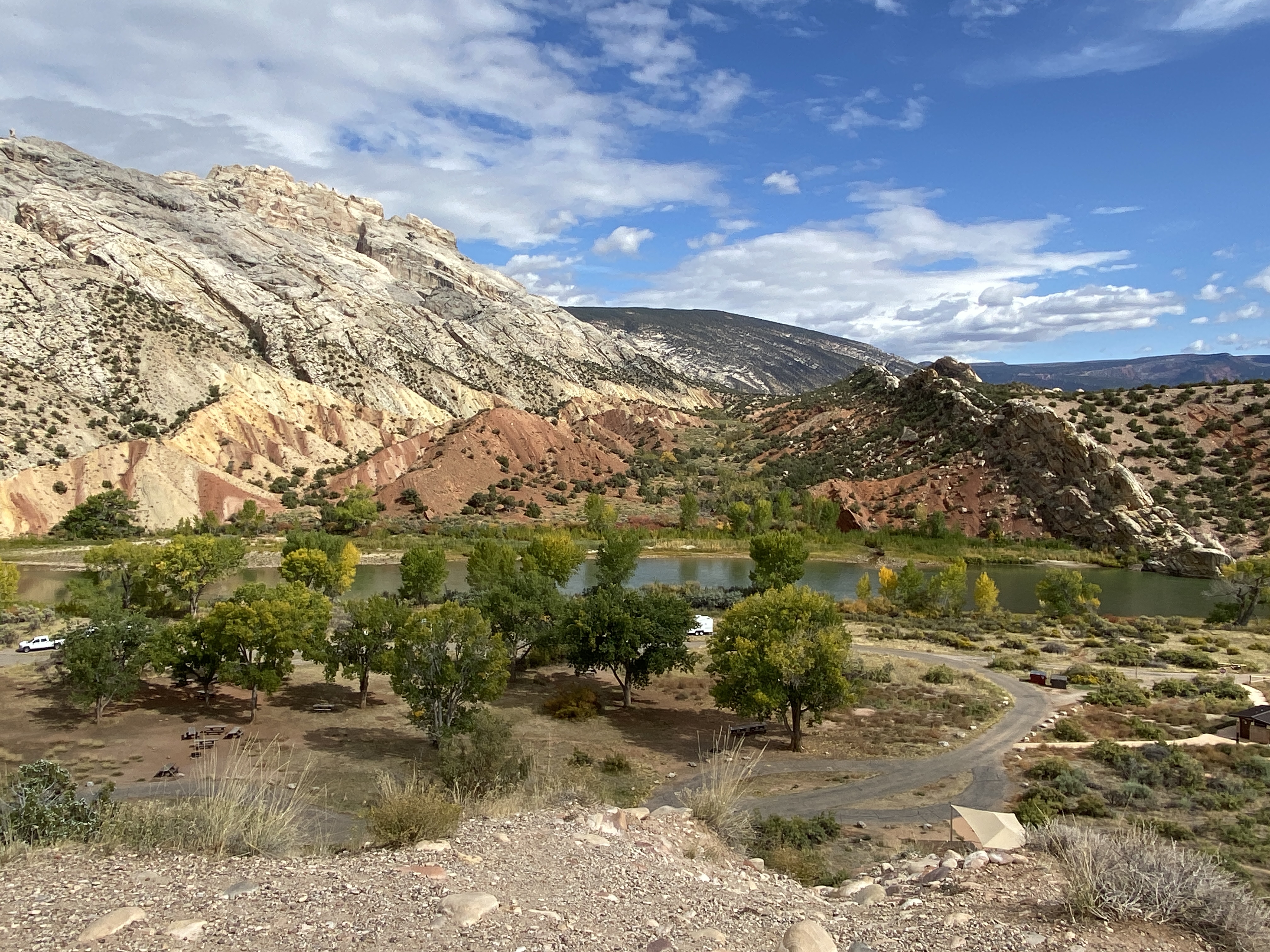
| The Green River |
Around all of this, are stunning rounded hills with millennia
of strata rolling along them. Split
Mountain is roughly eroded with spikey crags.
The Green and Yampa Rivers flow through this landscape. If you watched the Ken Burns documentary on
the National Parks, you might remember that in the 1950s there was an
unsuccessful plan to build a dam at Echo Park in the Colorado side of the park and
flood the beautiful canyons there.
 |
| Layers erode at different rates |
 |
| 'Turtle Rock' is made of the same Entrada Sandstone as you find at Arches National Park |
Butch Cassidy, other outlaws, including a group known as “The
Wild Bunch,” and cattle rustlers hid out here.
The notorious, backcountry Outlaw Trail linking Montana to New Mexico
drove through this region. The outlaws befriended
local folks, including the Bassett family.
Somehow, the Bassett’s cattle never got stolen.
One Bassett daughter, Josie, later in life moved to the base
of Split Mountain and set up an isolated homestead in 1914 where she lived
until she died at 89. The location of her
ranch is part of the park, and her cabin is currently being restored. She corralled her livestock in a box canyon,
just fencing the opening and using the 3 steep canyon walls to confine her animals. She avoided water rights issues by digging
ponds and dams to contain stream water on her property. Her ingenuity, hard work, and challenges are
examples of the experiences of early pioneers.
 |
| Split Mountain |
Dinosaur National Monument did not have many visitors while
we were there. It is far away from towns
and Interstate highways, and worth the effort to get there. We camped in
Outlaw Trail RV Park, near the entrance road into the park.
 |
| Elephant Toes Butte |


.HEIC)


