|
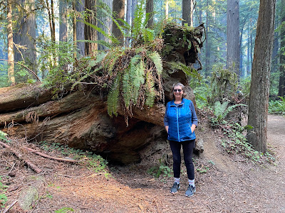
| Gigantic Coastal Redwood root ball |
Just Wow!!! The
Coastal Redwood trees are dramatic and beautiful. The North California Coast is also dramatic
and beautiful. We spent 4 days exploring
this beautiful part of our beautiful country.
(Do I get an award for using the word beautiful four times in the first
30 words of this blog post?)
 |
| Foggy Bodega Bay Marina |
 |
| The rugged, foggy Pacific coast |
We joined the California coast in foggy Bodega Bay. Most of Bodega Bay is perched on a cliffside,
and the restaurants have tiny parking lots.
We drove down to the marina area where there were spots big enough to
accommodate us as well as seafood restaurants.
We got food for lunch, and chowders to save for dinner. Does Bodega Bay sound familiar to you? Alfred Hitchcock’s movie, The Birds, was
filmed there.
 |
| Point Arena Lighthouse |
 |
| Yes, those are pelicans... |
We continued along the foggy coast and camped that night at
the KOA near Manchester State Park, and went looking for the Port Arena
lighthouse in the fog the next morning. The
setting is scenic, even in the mist.
 |
| Beautiful sea vista |
The fog lifted on our second driving day revealing rugged
sea vistas viewed from the top and sometimes from the sides of cliffs on Route
1. The road cuts inland after Fort Bragg
and winds its way through scenic second growth Redwood forests, up and down
steep slopes of the Coastal Range of mountains toward Route 101 which takes you North again.
Note to RVers- this is a white-knuckle drive on a very narrow, very
windy road with no shoulders and steep drop offs. Not recommended for the faint of heart.
The California coast is rocky, with cliffs overlooking gravel
or coarse sand beaches. The Pacific
Ocean slams huge waves against rocky outcroppings with tall sprays of water. There is always a roar of the ocean beating
against the shoreline.

We learned about treacherous Sneaker Waves (sometimes called
Sleeper Waves or Rogue Waves) – waves of water that do not break on the shore,
but instead continue in toward the beach and carry people and dogs out to
sea. Survival in the cold Pacific waters
is unlikely. There are signs on every
beach warning you to never turn your back on the ocean. Rather than swim Schooner here, we found a
quiet lagoon cut off from the ocean for her to retrieve her ball from the
water.
 |
| No that isn't an optical illusion, that tree is really that big |

The Coastal Redwood trees thrive in the misty fogs of the
coastline. Warm inland air passes over
the frigid ocean waters generating fog and providing precious moisture to the
trees. Scientists say that this climate
pattern approximates the mild, moist climate of the Dinosaur Age, when these
majestic trees grew all over North America.
Now they are confined to a narrow strip along the northern California
coast.

Coastal Redwood Facts
·
Can live to be 2000 years old, and average
500-700 years.
·
Grow to nearly 380 feet tall (tallest tree on
earth)
·
Can be 22 feet in diameter (although some are bigger)
·
Do not suffer insect damage or have killing
diseases
·
Sprout from seed, stump, or off the base of the
tree
·
In 1800, covered 2-million acres, about 100,000
acres remain today
 |
| This tree grew from another tree |
 |
| These trees are growing from a stump |
After the California Gold Rush played out, fortune hunters turned
to logging precious Redwood trees. In
1920, California preserved a few old growth groves of the trees in a series of
state parks. The US Congress created
Redwood National Park in 1968, surrounding three of these State Parks,
protecting additional trees and also an important salmon fishery. The four parks are operated collaboratively,
so you will see rangers in California State Parks and National Park Service
uniforms throughout the parks. The
Redwood National and State Parks protect about 40,000 acres of these ancient
forests.
 |
| The Newton B. Drury Parkway through Prairie Creek Redwoods State Park |
 |
| Circle Trail |
 |
| The "Big Tree" |

We explored the Prairie Creek Redwoods State Park. It has a drive through the forest with parking pull-offs at trail heads. Every tree along the road seems larger and more stately than the previous tree. There is a Circle Trail that is well maintained and flat. Needless to say, it is also quite popular. It takes you by the “Big Tree” – height 286 feet and diameter 23.7 feet.
 |
| Roots in the trail |
 |
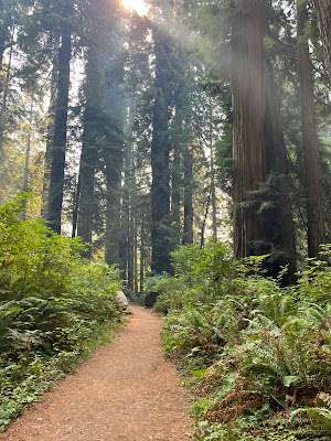
| Cathedral of Trees Trail |
We
turned off the Circle Trail to the aptly named Cathedral of Trees Trail. The first thing we noticed away from the
crowded trail was the quiet and serenity in this forest of enormous trees. The narrow trail was seamed with tree roots
and rocks. Gigantic root balls and
fallen tree trunks supported the life of new trees. We were awe-struck.
 |
| Yurok plank house - Sue-Meg State Park |
We camped outside Trinidad at Sounds of the Sea RV Park, where we
heard, but couldn’t see, waves splashing and sea lions barking. The campground is near Sue-Meg State Park. Sue-Meg and other State Parks in the area
honor the Yurok people who along with two other native tribes lived in this
area. It has a reconstructed plank house
Yurok village that is used today for tribal ceremonies. It also has trails to dramatic rocks, beaches
and overlooks.
 |
| Yum! |
 |
| Trinidad harbor |
 |
| Trinidad lighthouse replica |
The town of Trinidad is located on a scenic

You can not reach this region by vehicle without driving on
a twisty, mountain road. When we left, we
headed east on winding Route 299, which is wide, has passing lanes for slow vehicles on
hills, and (most importantly) has shoulders.
After Route 1, this road was a luxury!
 |
| Overlooking the beach at Sue-Meg State Park on a windy day |