Breathtaking.
Mesmerizing. Remarkable. Memorable.
Crater Lake is an exceptionally beautiful place and also a geological
novelty. [Most of what we know about
geology was taught to us by the National Park Service, and this is no
exception.]
Mount Mazama is part of the chain of volcanic mountains in
the Cascade Range. A few of the other
notable volcanoes in this range are Mount Ranier, Mount Hood, Mount St. Helens,
and Mount Shasta. About 7,700 years ago,
12,000 foot tall Mount Mazama erupted.
Pumice and ash flew into the air and flowed down its sides. After the magma chambers emptied, the
mountain could not support its own weight and fell in on itself, forming a deep
basin or caldera where the mountain peak had once stood.
The eruption was witnessed by native people from what is
believed to be four tribes, including the ancestors of the current Klamath
tribe. Their oral tradition about the
eruption matches closely with what scientists believe happened. The lake has been and continues to be an
important part of tribal practices.
The caldera has filled with centuries of snowmelt and rainfall, to form the deepest lake in the
United States. It is 1,943 feet deep at
its deepest point. No streams feed or
empty from the lake; the consistent water depth is maintained by precipitation
and evaporation. The water is
exceptionally clear and bright blue in color.
 |
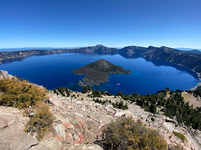
| Wizard Island is a volcano within a volcano |
 |
| You can see the crater at the top of the cone |
While the lake was filling with water, other smaller volcanoes
erupted inside the caldera. One formed
what is known as Wizard Island. It looks
like a mini-volcano floating in the lake.
The others formed cones under water. You can see the crater in the top of Wizard
Island from above.
Early in the history of the park (1888-1941) the lake was
stocked with game fish to improve the lakes recreational value. Previously, Crater Lake was without
fish. They also stocked it with crayfish
to provide food for some of the game fish.
Today, two of the fish species, rainbow trout and kokanee salmon, and
the crayfish still remain in the lake. Scientists
are studying the consequences of importing these fish into the pristine
lake. We question how anglers would have
been able to get down the steep sides of the caldera to the water’s edge to
fish, or more importantly how they would get their boats down there?
 |
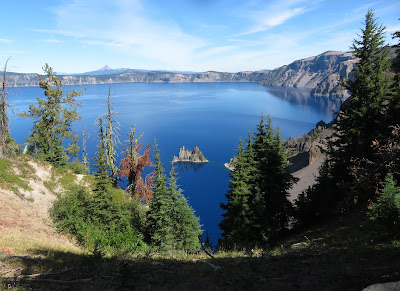
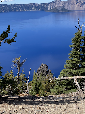
| Steep sides to the caldera, Phantom Ship in the foreground |
When you visit Crater Lake, you hike or drive around the rim
of the volcano, looking down at the water.
The sides are steep and often covered with loose rock. There is only one place where you can hike
down to the waters edge. It is termed to
be the most strenuous hike in the park with an elevation change of 700 feet in
1.1 miles. Hardy hikers can hike down
and take a boat ride out to Wizard Island and hike or swim there. We decided not to try it.
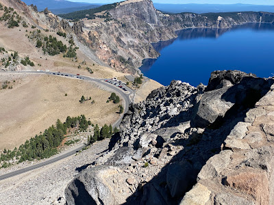 |
| A view of the Rim Drive |
 |
| And another... |
The Rim Drive encircles the lake. Sometimes it is close to the edge of the rim,
and sometimes it travels around a ridge and away from the lake. There are many pull-offs to admire features
of the lake, some right next to the road, and some with short hikes from the
parking lot. Every view of the lake is a
picture postcard moment. While we were
there a portion of the East Rim Drive was closed for maintenance.
 |
| Crater Lake Lodge |
We camped outside the park at the charming Crater Lake
Resort. It is located in a very flat area
at about 4,000 feet in elevation 25 miles from the South Entrance to the park,
which is actually a ways inside the park boundary. As soon as you enter the park, the road
starts to climb. The Rim Village with a
café, gift shop, visitors center, and the historic Crater Lake Lodge is at
7,100 feet of elevation.
 |
| Eyeing our grapes... |
We explored the Rim Village on our first morning in the
park, then we set out on the East Rim Drive.
We stopped for a mid-morning snack at a picnic area along a ridge. It was tranquil and quiet until we opened our
container of grapes for our snack. We
were visited by four very forward Jays, who took turns hopping around on the
table eyeing our grapes then flying to a neighboring tree and being replaced by
another Jay or two. Obviously, these
birds had been fed by humans. We closed
our grapes up and left them to fend for themselves in the wild.
 |
| The Phantom Ship |
We hiked a loop trail in Sun Notch through a lovely meadow
and out to several remarkable viewpoints of the Phantom Ship. This is a lava remnant of a volcanic cone
that precedes the time of Mount Mazama.
It is the oldest rock in Crater Lake.
It looks kind of like the Black Pearl in “Pirates of the Caribbean”
movie. The views from above with the
reflection in the lake are spectacular.
As you drive further, there is an overlook with yet another view of the
Phantom Ship.
 |
| The Pumice Castle |
Another feature seen at the Phantom Ship Overlook is the
Pumice Castle, an orange outcropping of hardened pumice in a landscape of
greys. While it is named a castle, it
looks like a hoodoo to us.
On our second day, we explored the West Rim Drive. This drive gives you many, wonderful views of
Wizard Island. There is a hiking path
from the Rim Village that parallels the road and runs closer to the edge of the
rim in some spots. We hiked along it for
a while enjoying the views.
 |
| The Watchman trail takes you past stone left behind by the eruption |
 |
 |
| The watch tower at the top of the Watchman |
 |
| The view from the top of the Watchman |
The Watchman is an 8013 foot peak that got its name when it
was used by the US Geological Survey as a watch point while surveyors sounded
the lake depths in 1886. There is a
stone tower at the summit built in the early 1930s to spot fires. The hike is considered “moderate” at .8 of a
mile each way and 420 feet of elevation change.
The view from the top is glorious.
It is a popular hike, so we shared the tower patio with a lot of other
hikers.
There really is no place we have visited quite like Crater
Lake. Is it on your bucket list? We hope you enjoyed the photos in this post; we
took 100’s. Such a beautiful place!





No comments:
Post a Comment