Saturday, September 21, 2024

Kayaking Kettle Ponds – Cape Cod National Seashore MA – September 19, 2024


Getting ready to head out


The interior of Cape Cod is pock marked with about 365, round(ish), fresh-water ponds called kettle ponds.  They were formed when the ice sheet that formed Cape Cod retreated 18,000 years ago.  The ice sheet left behind great chunks of ice, that slowly melted and created deep ponds whose bottoms intersected with the fresh water aquifer.  The ponds have no in-flow sources of water, and only a few have an out-flow.  They are replenished by rain water and the water table.


We explored Gull, Higgins and Williams Ponds

We signed up for a National Park Ranger-led kayak paddle across three of these kettle ponds.  The trips are very popular, you can only sign up for them starting a week in advance, and they usually fill up the first day the list is open.   


Beautiful  tree-lined Gull Pond

We met at Gull Pond, which has a public parking lot, many of the kettle ponds do not have public access.  It was the first day of what was to become a 3+-day rain and wind storm.  We dressed in our kayak gear covered with rain pants and coats.  Only 5 of us showed up - 6 others had dropped out.  We were accompanied by a Ranger and a volunteer guide.


Gull Pond


Gull Pond is a beautiful, small, round lake.  It is surrounded with trees and a few summer cottages.  Some of the cottages have small boats pulled up on shore.  Back in the day, summer visitors came to Cape Cod to stay on the kettle ponds.  No one went to the beach and ocean except to fish or collect seaweed for the garden in those days.  After all, the ocean was full of seals and great white sharks, and was dangerous .[Note: the ocean is still full of seals, sharks and danger, just now days folks WANT to be on the beach and swim in the ocean.]


After the National Seashore was founded in 1961, no new dwellings were built within the seashore boundaries.  So, no new cottages will ever be built on these kettle ponds.  In 1961, there were almost no trees on Cape Cod.  It had been deforested for lumber for ships, buildings and fuel.  Under the National Seashore protection, forests have returned, and the trees are plentiful.  Cottages that once had a clear view of the water, now peek at it through the trees.


Gull Pond/Higgins Pond portage

We dragged our kayaks through a narrow sluice way between Gull Pond and the smaller Higgins Pond.  Higgins Pond is also connected with Herring Pond, which is connected via the Herring River to Cape Cod Bay.  Herring travel up the river to spawn in these freshwater ponds each Spring.


Water lillies approaching the Higgins/Williams portage

Higgins Pond is lined with lovely water lilies, with a few closed blossoms left in mid-September.  Higgins Pond has regular summer cottages and a few Cape Cod Modern Houses built around 1960.  These Bauhaus influenced houses were built with cheap or found materials.  They are boxy with simple lines, and large windows overlooking the ponds.  There are seven within the National Seashore boundaries, and a local Trust is buying and restoring them.  Some can now be rented from the Trust as vacation rentals.  We could see the few on this pond through the trees.


Late, late summer bloom

From Higgins Pond we made a portage over a narrow sluice to even tinier Williams Pond.  Williams Pond has even more water lilies.  The detritus from the water lillies has been accumulating on the bottom, and Williams Pond is no longer as deep as it once was.  You can see along its banks the 18th century home of John Newcomb, a Wellfleet MA oysterman.  Henry David Thoreau describes staying with Newcomb in 1849 in his book Cape Cod.


Sorry for the water on the camera lens in these photos - it was raining

While we were in Higgins Pond, we could hear the surf crashing on the beach.  It sounded like it was almost on the other side of the trees.  It is always fun to be out paddling on the water, even in winds and heavy rain.  As we write this 2 days later, our leather kayak gloves are still wet, hanging from the shower curtain rod in the motorhome.


Friday, September 20, 2024

The Brave Surfmen at the Old Harbor Life-Saving Station – Cape Cod National Seashore MA – September 15, 2024


The Old Harbor Life-Saving Station at Race Point

The seas and sand bars off Cape Cod, a lonely peninsula sticking 25 miles out into the Atlantic Ocean, were treacherous to mariners.  3000 sailing ships ran aground on the shifting sand bars off the beach, and were often pounded apart by furious seas during violent storms. 


In 1877, the US Government created the U.S. Life-Saving Service to protect Cape Cod and other dangerous coastlines.  There were 14 Stations along Cape Cod.  They were built about 4 miles apart.  The Stations were staffed with an Officer (called the Keeper) and 6 surfmen.  They lived in the Station year-round, except for two months in the summer when they went home.  During the days, they would follow a strict regimen doing lifesaving drills and maintaining equipment. 


Surfmen prepared their meals on a coal stove.  

The Keepers quarters.  Coal hub heaters warmed the rooms.  Each station used an average of 16 tons of coal a year


Each night, surfmen would walk two miles (one headed in each direction) away from the Station, meeting up with a surfman who was walking from the next Station down (or up) the beach at a small halfway house.  They would exchange badges to prove they had made the walk, and then return to their respective Stations.  Upon their return, another set of surfmen would retrace the walk.  This was exhausting work, particularly during a storm.  If a surfman spotted a wreck, he ignited a flare.


Oar-powered rescue boat

Larger engine-powered rescue boat


Surfmen would drag, or use a horse to pull, rescue boats from out of the Station to the water’s edge.  They would row out into the storm, bringing back 5 shipwreck victims at a time in the small boat.  Later boats had engines and propellers.  The small size of the boat, and the few number of people who were rescued at a time, meant that the surfmen had to repeat the dangerous trip out to the wreck multiple times.


The shot line for the breeches buoy was carefully wrapped in the "faking box" so that it would not become tangled  

If conditions were too risky for a rescue boat, they used a contraption called a breeches buoy, basically a life ring, with a pair of canvas breeches fastened inside.  The surfmen would use a small cannon called a Lyle Gun to shoot a light weight line and pulley system from the shore to the ship.  The ships’ crew would attach the line to the ship, and the surfmen would erect a 12-foot-tall wooden crotch on the shore to suspend the shore end of the line.  Then, one victim at a time would “sit” in the breeches buoy and be pulled to shore.


The locations of the US Life-Saving Stations on Cape Cod and the Islands

In 1914, the Cape Cod Canal was opened, and ships could travel safely between New York and Boston without going around the Cape.  The Life-Saving Stations were disbanded on the Cape.  In 1915, The U.S. Life-Saving Service was incorporated into the U.S. Coast Guard.


While there was a Life-Saving Station at Race Point, the Old Harbor Station building located there now, was originally built and used further down the Cape in Chatham.  It was moved to the current location in 1978.  It is the last remaining Life-Saving Station on Cape Cod.


Note the huge sand dune on the left that has grown between the Station and the beach

When it was relocated, the Old Harbor Station building was placed close to the waters' edge on the beach, as the original Station would have been, giving the surfmen easy access to move their boats from the building into the water.  In the almost 50 years since then, a huge dune has formed between the shoreline and the Station.  Proof that Cape Cod is always changing, and that its sands are always shifting.


All you can see of the Station behind the dune from the beach

The Chicamacomico Life-Saving Station in Rodanthe, NorthCarolina is also open to the public, and a favorite stop of ours.  Both Station museums honor the brave men who risked their lives in incredibly dangerous circumstances.


Tuesday, September 17, 2024

A Tale of Two Lighthouses - Cape Cod National Seashore, MA September 10-12, 2024


Highland (Cape Cod) Lighthouse

Outer Cape Cod is beautiful.  The narrow outermost end of this 60-mile-long, curved peninsula is lined with mountainous sand dunes, in some places covered with trees, that fringe wide sand beaches along the Atlantic Ocean on one side and Cape Cod Bay on the other. 


Cape Cod has an iconic fish hook shape.  "Outer Cape" is what they call the curved pointy end of the hook.  It, and other areas further down the Cape, are the home of the Cape Cod National Seashore.  The Cape's close geologic and historic connection to the sea is best described by the many lighthouses that protect mariners along its coast.  We visited two of the four on the Outer Cape.


Highland Lighthouse from the rear 


The Highland Lighthouse is less than a mile from where we are camping in the town of North Truro. It is sometimes referred to as the Cape Cod Light because it is often the first light seen by mariners approaching Cape Cod from Europe. 


The view from the top

Highland Lighthouse was built at the top of a 125-foot clay cliff.  This part of Cape Cod erodes at a rate of 2-3 feet a year, and the 1831 brick structure eventually became perilously close to the edge.  So, in 1996 it was moved back 450 yards from the edge.


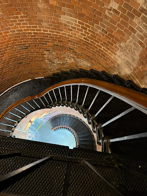
The lighthouse and part of the lighthouse keepers’ home are open to the public.  We climbed the 66 stairs up the 60-foot-tall structure to enjoy the beautiful view. 


Highland Light stairs

Near the lighthouse is Highland House, an old tourist guest house that is now a museum, and the historic Highland Golf Links 9-hole golf course.  It was interesting to approach the lighthouse with golfers playing on both sides of the path.


Race Point Lighthouse

While you can drive your car on roads to the Highland Lighthouse, you must use a 4-wheel drive vehicle or hike out to reach the Race Point Lighthouse.  Race Point is located at the furthest most point of the “fish hook” before it curves back on itself.  It is named for the strong tidal currents or “races” that make navigation around the tip of Cape Cod so treacherous.


The start of the walk

You time our hike at low tide, because that allows you to cut across an area of tidal wetland that is drained when the tide goes out.  It is about 1.5 miles each way.  At high tide, the walk is much longer.  The tides are 7 feet here.


Beautiful marshes as the tide recedes

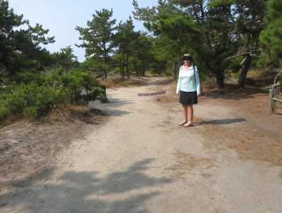
The walk starts at the tiny Hatches Harbor parking lot.  The trail takes you through the woods, then along an elevated dike across much of the wetlands.  This part of the hike is lovely and scenic.  Most of this section of the walk is through loose sand, so it is slow and strenuous going.


Climbing the dunes

Then you slide down the side of the dike and traipse across the emptied wetland.  At the other side, you scramble back up over the dunes (more loose sand) to arrive at the lighthouse.


So pretty, so isolated

The lighthouse was not open when we were there, though it is open for tours 2 Saturday’s a month.  The lighthouse keepers house operates as an inn.  If you have a four-wheel drive vehicle, you can stay out there at the edge of the world.  We heard from someone that guests at the inn have seen whales swim by from their windows.  Imagine!


We continued along the 4-wheel drive road (more loose sand) to a lovely beach hosting a few beach goers and fishermen who found their way there by truck.


Saturday, April 27, 2024

Crane Point Hammock Museum and Nature Trails - Marathon, Florida [April 23, 2023]


Endangered Florida Thatch Palms

Before settlers came to the Florida Keys there were areas of abundant hardwood forest, that are called “hammocks”.  63 acres of hammock containing rare and endangered trees and plants are preserved in the Crane Point Hammock Museum and Nature Trails.  


Calusa canoe

Native Calusa people were the first to use the area as a fish camp, and left some artifacts behind. 


Adderly House, the only tabby structure left in the Keys

The first permanent settlers were a Black Bahamian, George Adderly, and his wife Olivia who purchased 32 acres of Vaca Key for $100 and then built a tabby house in 1903.  Tabby is a kind of homemade cement made out of lime, created by burning wood and shells at high temperatures, mixed with sand and water.  Rocks and shells are put in to give it more mass.  The house is the oldest house in the Keys outside of Key West and the only tabby house remaining in the Keys.  The house has two main rooms and two bedrooms.

Adderly used this "creek" between Vaca and Rachel Keys to navigate to Florida Bay to havest sponges and to sail to Key West

Adderly collected sponges and made charcoal, and sailed his boat periodically to Key West to sell them and buy provisions that he and Olivia could not make on their own.  When the railroad came through, he negotiated a right of way that included a stop on Vaca Key, so he could use the railroad to travel to Key West more efficiently. 

This guy came to visit us at Adderly House.  We were told that racoons don't carry rabies in the Keys.


George Adderly was an Episcopal lay preacher who held services in his home.  At some point, a few other families built wooden houses near his on Vaca Key, forming Adderly Town.  All that remains of these homes are a few tools and household utensils found on the property.  

Built in the Bahamian style, every door or window has a corresponding opening on the other side for ventilation.


Olivia died in 1948 and George sold the property to the Crane family in 1949, moving to a home for the blind in Key West, where he died ten years later.


Crane House

Francis and Mary Crane were a Massachusetts couple who fled the New England winters, much as many “snow birds” do today.  They purchased Rachel Key in 1949.  When they purchased the adjoining Vaca Key from Adderly, they consolidated 63 acres of natural hammock.  The land was renamed Crane Point, and they built a house overlooking Florida Bay in 1954.


Crane Point (with old work boat)


The Cranes worked to preserve the special ecology and beauty of their wooded hammock.  All around their oasis, forests were being bulldozed in Marathon to make way for homes, hotels and businesses as more people discovered the Keys as a destination.


Beautiful hardwood hammock

In 1978,  the property was purchased by the newly formed Florida Land and Sea Trust to protect it from development.  The Crane Point Hammock Museum and Nature Trails has a natural history museum, the two historic houses, several miles of nature trails, and other educational and environmental activities.  Both the Adderly House and the Crane House are on the National Register of Historic Places.  You can walk through the Adderly House.  The Crane House has scheduled tours.


The museum has beautiful bronze doors

It was too windy to be out on the water, so we decided to head into Marathon to explore Crane Point, go grocery shopping and have lunch at a Cuban restaurant.  Crane Point has well maintained hiking trails that take you through the forest, past the historic houses, and along the point.  You can learn about interesting trees through signs along the way.


Black Mangrove "straw" roots snorkel up out of the water or mud to get oxygen

Crane Point is right off of Route 1 in the center of Marathon.  There is a shopping center with a grocery story directly across the street.  Marathon is a busy city at the north end of the 7-mile Bridge with an airport, hotels, time shares, condos, restaurants and businesses.


Dense foliage

After spending so much time on the edge of the ocean, it was really fun to have closer vistas of dense foliage, and the background songs of birds.  We love the stories of these kinds of parks, where individuals work to preserve a special, natural place. 


This huge spider built its' web across the trail!

Sunday, April 21, 2024

At Last! The Dry Tortugas National Park, Florida! [April 18, 2024]


Approaching Fort Jefferson 


7 tiny coral and sand keys 69 miles west of Key West, sitting by themselves at the entrance to the Gulf of Mexico were considered to be of such strategic importance that in 1846 the US Army started building what would become the largest brick structure in North America, Fort Jefferson.  Today, that fort and the surrounding keys and waters are protected as the Dry Tortugas National Park. 

Fish swimming outside the outer wall of the fort


We went to tour Fort Jefferson and to snorkel in the ocean waters along the outside of the fort to see the creatures that have taken up residence in the crevices along the masonry structure.


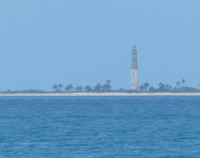
Fort Jefferson lighthouse

The Dry Tortugas were named "Los Tortugas" by the Spanish explorer Ponce De Leon who marked them on the nautical chart as being a location where mariners could find an important food source, green sea turtles.  Subsequent mariners added “Dry” to the name, because none of the keys have a source of fresh water. 


Lighthouse built on Loggerhead Key in 1857

These keys are at the end of a curved coral reef that extends south and west from Miami.  Ships sailing into or out of the Gulf of Mexico had to sail around them to avoid hitting the submerged reefs and sinking.  Also, the powerful Gulf Stream flows nearby that mariners used to assist them as they traveled up the East Coast and over to Europe.  Ships carrying goods that came down the Mississippi River to New Orleans for markets on the East Coast or Europe sailed right by these keys.  Also, ships bringing goods into New Orleans sailed past them as well.  They were a very strategic location.

The Sally Port is the only entrance/exit to the fort

The Dry Tortugas also provided natural deepwater harbors surrounded by shoals that US military ships patrolling these important shipping lanes could use to get supplies, make repairs or seek refuge during storms.


So many bricks

The army started building the enormous (16-acre) Fort Jefferson in 1846.  Everything that they needed to construct the fort had to be brought in by sailing vessel.  All that was there was saltwater, sand, coral and a few scrub trees.  Imagine the logistics of importing the 16 million bricks that were used, not to mention the special stone floors that withstood the force of cannons firing, or the cannons themselves.


Imagine unloading this huge cannon off a ship

The fort was designed to withstand a one-year siege.  An elaborate drainpipe system collected rain water from the fort’s top tier, filtering it through sand and collecting it into 109 cisterns located below the fort’s first level.  Over time, the cisterns were infiltrated with salt water, except for one 92,000-gallon cistern below the fort parade ground that is still in use today.

Intricate vaulting and brick work

During the Civil War, the fort was used as a prison for Union Army deserters.  It also housed four conspirators in the assassination of President Lincoln, including Dr. Samuel Mudd.

A moat surrounds the fort

The Army abandoned the fort in 1874.  The area became a wildlife refuge for a while, and then a National Monument.  In 1992, it became a National Park.


Part of the magnificent frigate bird welcoming party

In addition to the significant cultural heritage, the area is an important nesting area for masked boobys, sooty terns, brown noddys, and magnificent frigate birds.  When we arrived at the fort, the neighboring key, that was connected by a land bridge, was noisy with the calls of the nesting birds.  30 magnificent frigate birds glided silently overhead.


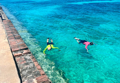
Snorkeling in the ocean outside the moat

Seargent majors


The fort has a moat around its 6 sides.  On 4 of these sides, the moat is surrounded by ocean.  You can snorkel along the outside of the moat wall.  Places where bricks have fallen out are now caves for fish and spiny lobsters to hide in.  The ocean floor is littered with brick and mortar debris that came out of the thick wall. 


Brain coral have colonized a masonry shelf

A colorful grunt fish


In one area, a whole vertical layer of brick work had fallen away, the resulting shelf was being colonized by brain coral and various soft coral species. 


We estimate this gigantic spiny lobster is over 2 feet long

These are BIG lobsters


We saw the largest spiny lobsters we have ever seen; they were easily over 2 feet long.  They live in protected waters in the park, so cannot be caught and eaten.  They live long, long lives.  Researchers have found that these giant lobsters are super breeders, with more offspring, and more offspring viable to survive.  It was an interesting study to learn about.  Especially when we saw how big they can grow.


The Yankee Freedom Ferry

The Dry Tortugas can only be reached by boat or sea plane.  You have to plan well in advance to visit there.  You can take the Yankee Freedom Ferry out of Key West, which takes only 175 lucky people there each day.  This is our 4th RV trip to the Florida Keys, and on each previous trip we were unable to get tickets on the ferry. 

Or you could charter a sea plane
 

This year, we made our reservations for tickets three-months in advance, in January.  If you don’t have tickets, you can arrive at the ferry terminal early to put your name on a waiting list in case someone who bought tickets does not show up.  On our trip, 2 people got on the ferry that way.  They had arrived at the terminal at 5:15 AM.


A view of the moat

We are camping 39 miles from Key West.  We left our campsite at 5:30 AM, dropped Schooner off at a pet sitter 3 keys down, and drove to Key West arriving at 6:30.  We parked at a garage a block away. 


Thick walls protect the Powder Magazine

You have to check in to the ferry by 7.  The ferry loads at 7:30 and departs at 8.  They provide you with a bagel breakfast, with fruit and juices.  [As a note, they provide alternative foods for visitors with dietary concerns, you just tell the crew member in the galley what you need.]


During part of the 2.5 hour trip, Hollywood (our tour guide) talked to us about the history of the park and what to expect while we were there.  We arrived at 10:30.  At 11:00, Hollywood gave a fascinating 30 minute orientation to the fort.  He also led a subsequent 1-hour tour of the fort.  Instead, we went back to the ferry to pick up a bag lunch, and ate our lunch in the fort courtyard and explored the fort on our own. 


At about 1:00, we went to the beach, and snorkeled for an hour or so.  Then we changed into dry clothes, and boarded the ferry for the ride back, departing at 3. We arrived back in Key West at 5:30, picked up Schooner and got back to our campsite at 7. 


The view from walking along the moat wall (yes, that's us).
Photo courtesy of Jeff and Didi Davis

The ferry loans snorkel gear for folks who do not bring their own.  Many of the people who did not wish to swim or snorkel, walked along the top of the moat walls, looking down at the sea creatures living in the moat, and also the animals we were seeing outside the moat as we snorkeled. 


It is was an amazing and exciting day.  Someone said to me that you have to be “intentional” to visit the Dry Tortugas, and you do.  You need to plan well ahead.  It is certainly worth the effort. 

We have finally visited Dry Tortugas National Park!